

 Below is a list of informative resources to share with your community. All items are free to download and print. The items described as "for home printer" can be printed on any home printer. Those items described as "for print shop" can be provided to a printer for professional-looking brochures (i.e. with bleed.)
Flyers
With most of our flyers, we provide versions suitable for both a home printer and a professional print shop. Our top recommended picks are in red.
 Apartheid in Israel (5.5" x 8.5") This flyer explains why human rights groups assert that Israel imposes a regime of apartheid against Palestinians. (Published 2022)
For home printer | For print shop

 What is Palestine? (8.5” x .5.5”) This flyer describes Palestine geographically, historically and politically. A great resource to inform people unfamiliar with Palestine and/or the Israel-Palestine conflict. (Published 2022)
For home printer | For print shop
 Anti-Palestinian Racism (5.5” x 8.5”) This flyer presents and contextualizes the the problem of anti-Palestinian racism in Canada. A great resource for all, whether Palestinian, Arab, or newbie to the Israel-Palestine discussion. (Published 2022)
For home printer | For print shop
 BDS Basics (8.5” x 5.5”) This flyer explains the BDS movement, how people can get involved, and why BDS makes sense for Canada and Canadians. (Published 2022)
For home printer | For print shop
 BDS In Depth: International Law and Palestinian dispossession (11” x 8.5”) This large-format flyer goes into greater depth explaining why BDS makes sense on the basis of both international law, and official Canadian policy. It also presents BDS in the broader context of Israel's ongoing dispossession of Palestinians. (Published 2017)
For home printer | For print shop printer
 Disappearing Palestine Card (8.5” x 3.66”) This card provides the four maps depicting Israel's confiscation of Palestinian land over the decades. (Published 2020)
For home printer | For print shop
 Human Rights in Israel-Palestine (11” × 8.5”) This brochure, intended to be folded in the middle, presents a broad and informative description of Israeli human rights abuses against Palestinians. (Published in 2017)
For home printer | For print shop
 Illegal Israeli Settlements in the West Bank (8.5” x 11”) This flyer provides an map of Israel's oppressive "matrix of control" over Palestinians in the West Bank. (Published 2017)
For print shop
 Brochure: Anti-Arab Racism in Canada (11" x 17") This brochure, intended to be folded in the middle, presents the results of a 2021 CJPME survey on racism against Arab-Canadians in a very visual and striking way. (Published in 2021)
For print shop
 Remove the JNF's charitable status (11” × 8.50”) This flyer presents the many reasons why the Jewish National Fund should not qualify for the benefits derived from holding charitable status with the Canada Revenue Agency. (Published in 2017, in collaboration with Independent Jewish Voices.)
For home printer | For print shop
BDS sticky notes
All sticky note files are sized at 4" × 4" and formatted for professional print services. Work with a vendor of 4"x4" custom sticky note pads to be able to use these files.
 International Law Theme (English) Sticky note text: "Made in Israel: A country violating international law, the 4th Geneva convention, and fundamental human rights."
For print shop only
 Dispossession Theme (Billingual) Sticky note text: "Made in Israel: A state with laws promoting ethnic discrimination..." | "Fabriqué en Israel : Un État qui promeut la discrimination ethnique..."
For print shop only
 Dispossession Theme (English) Sticky note text: "Made in Israel: A state with laws promoting ethnic discrimination..."
For print ship only
CJPME Foundation Resources
The CJPME Foundation has curated a collection of maps comparing Indigenous dispossession in Canada and Palestine.
Click here to see the collection and download the images for various uses.
Maps
Click on the images to download in another tab.


Map 1: Following World War II, land ownership in Israel-Palestine was roughly 6% Jewish, and 94% Palestinian. This, despite massive emigration by Jews to the region in the decades prior.
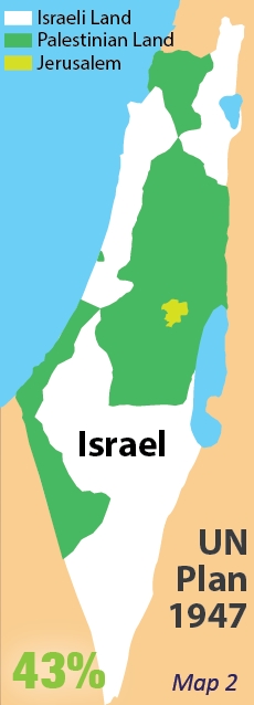
Map 2: The UN Partition Plan of 1947 allocated 53% of the land to a Jewish-majority state, and 47% of the land to a Palestinian-majority state. At this time, the Jews only represented 33% of the population of Israel-Palestine. Western countries voted in support of the Plan, while almost all Asian and African countries voted against it.
Map 3: In the armed conflict of 1948, Israel defeated its opponents, and seized vast amounts of land intended for the Palestinian-majority state. At least 700,000 Palestinians became refugees between 1947-1949, yet Israel has never permitted these refugees to return. In 1967, Israel invaded the West Bank and Gaza, and has militarily controlled these territories ever since.
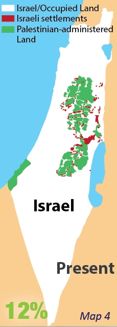
Map 4: With its military occupation of the West Bank, Israel continues to confiscate land with illegal Jewish-only colonies (a.k.a. "settlements"), Jewish-only roads, "security" zones, and a 700-km Wall. Palestinians are separated from their lands, their schools, health services, and neighbouring communities by what some now call Israel's "matrix of control."
For more information and diagrams on the history of Israel-Palestine, click here.
For more maps of Israel-Palestine, click here.